Cavechat.org
The Official Caving Forum of the National Speleological Society
NSS Home Page |
Flickr NSS Photo Pool | Online Cavers Network
CaveChat Room |
NSS Bookstore | Find Local Caving Club
Surveying large passage for the first time
Moderator: Moderators
Re: Surveying large passage for the first time
![]() by Chads93GT » Sep 12, 2012 7:21 pm
by Chads93GT » Sep 12, 2012 7:21 pm
-
Chads93GT - NSS Hall Of Fame Poster
- Posts: 2294
- Joined: Jun 24, 2008 1:27 pm
- Location: Missouri
Re: Surveying large passage for the first time
![]() by GroundquestMSA » Sep 12, 2012 8:56 pm
by GroundquestMSA » Sep 12, 2012 8:56 pm
Chads93GT wrote:Give the arbitrary station to a formation or whatever a number with decimal. Problem solved. I do it all the time. Simple problem and a simple solution. Don't over think it. Hehehe
A simple solution to a problem I'm not going to have. The only thing I'll be using my computator machine for is lettering. Perhaps I should have made it more clear that I'm looking for tips on gathering data and sketching, not making the map.
-

GroundquestMSA - NSS Hall Of Fame Poster
- Posts: 1384
- Joined: May 5, 2011 1:32 pm
Re: Surveying large passage for the first time
![]() by Chads93GT » Sep 12, 2012 10:02 pm
by Chads93GT » Sep 12, 2012 10:02 pm
-
Chads93GT - NSS Hall Of Fame Poster
- Posts: 2294
- Joined: Jun 24, 2008 1:27 pm
- Location: Missouri
Re: Surveying large passage for the first time
![]() by Martin Sluka » Sep 13, 2012 2:07 am
by Martin Sluka » Sep 13, 2012 2:07 am
lleblanc wrote:and I know Therion already recognizes them.
Just an example of PocketTopo sketch import to Therion map editor:

-

Martin Sluka - NSS Hall Of Fame Poster
- Posts: 402
- Joined: Mar 17, 2006 11:28 am
- Location: Prague, Czech Republic
- Name: Martin Sluka
- NSS #: 29010
Re: Surveying large passage for the first time
![]() by LWB » Sep 15, 2012 7:40 pm
by LWB » Sep 15, 2012 7:40 pm
But this is off topic. Good luck on surveying the big passage. I'll keep to the smaller stuff myself...
- LWB
- Prolific Poster
- Posts: 117
- Joined: Oct 29, 2007 7:36 pm
Re: Surveying large passage for the first time
![]() by lleblanc » Sep 16, 2012 9:09 pm
by lleblanc » Sep 16, 2012 9:09 pm
LWB wrote:I'm confused by the no splay shot support also. I've put them in Walls many times. I didn't know Compass didn't support them. But I've only used Compass once or twice (mostly while trying move Walls data into Auriga - it worked, but required hand editing the first station of every survey). Obviously PocketTopo does - that seemed to be a clear vision for the use of that program.
What is the confusion? I wrote that few PC programs support splay measures. Walls does, Therion too. Compass will eventually, VisualTopo doesn't. Any other? PocketTopo is not a PC program, it's a PDA app, just like Auriga. It makes sense PDA apps support them, they used in-cave, where sketching takes place.
-

lleblanc - Frequent Poster
- Posts: 87
- Joined: Aug 10, 2007 2:19 pm
- Name: Luc Le Blanc
Re: Surveying large passage for the first time
![]() by Jeff Bartlett » Sep 16, 2012 9:24 pm
by Jeff Bartlett » Sep 16, 2012 9:24 pm
-

Jeff Bartlett - NSS Hall Of Fame Poster
- Posts: 948
- Joined: Jun 29, 2007 12:19 am
- Location: Chattanooga, TN
- Name: Jeff Bartlett
- NSS #: 59325
- Primary Grotto Affiliation: Tennessee Cave Survey
Re: Surveying large passage for the first time
![]() by Bob Thrun » Sep 16, 2012 11:47 pm
by Bob Thrun » Sep 16, 2012 11:47 pm
Jeff Bartlett wrote:I just didn't realize that. You literally cannot enter splay shots into Compass? WTF?
Compass is perfectly capable of accepting splay shots. The user has to manually ovewrite the automatically generated station names. He may also want to set a Shot Flag for length exclusion. It is partly a question of terminology. When I do a survey shot to a point, any point, I consider that point to be a survey station. Luc Le Blanc considers the points at the far ends of splay shots to be non-station detail.
Luc Le Blanc speaks of "splay measures". After carefull reading his messages, I am not sure just what he means by that term. Apparently it implies special handling of splay shots, instead of just treating them as survey shots.
- Bob Thrun
- NSS Hall Of Fame Poster
- Posts: 322
- Joined: Jul 18, 2006 12:50 pm
Re: Surveying large passage for the first time
![]() by lleblanc » Sep 17, 2012 4:49 am
by lleblanc » Sep 17, 2012 4:49 am
Bob Thrun wrote:Luc Le Blanc speaks of "splay measures". After carefully reading his messages, I am not sure just what he means by that term. Apparently it implies special handling of splay shots, instead of just treating them as survey shots.
Bob is correct, and this must be the source of confusion: I use the words "splay measures" to differentiate them from ordinary survey shots between stations. Splay measures are just measures (...) taken between a survey station and some arbitrary non-station points (a rock, a formation, an angle in the wall, etc.) that only serve to display lines on the line plot to help with sketching. When done with sketching, these lines can be hidden without affecting the line plot (other than uncluttering it). These measures don't add up to cave development and don't create survey stations. View them as sophisticated LRUDs (left, right, up and down) measures, where headings and slopes are kept, not just their length. They can also be used to measure a cross-section, best done with a DistoX rotated perpendicular along the axis formed by a survey shot that follows the cave passage, so as to measure a "slice" of that passage; by acquiring several such measures, it's possible to get a refined view of the passage section, as if working with a point cloud mapper.
What is the benefit of preferring splay measures over splay shots? They:
* don't clutter the line plot with a bunch of lines only aimed at sketching (even worse if station numbers are displayed too!)
* dont' count in cave development and statistics
* don't mess the graph of passage trends (like Compass' rose diagram)
* don't use up station numbers
* don't extend the list of survey stations (requires more memory, takes longer to find a path)
* don't require marking additional stations (where this is standard practice)
* don't require backsights (where this is standard practice)
Auriga offers to qualify splay measures as pointing towards a wall, the floor/ceiling or some detail (ex. a rock in the middle of a room). This way, it knows whether or not to join these measures to the wall outline in top and profile views. Therion differentiates between detail and floor/ceiling/wall splay measures. As for PocketTopo, I'm not sure it differentiates whether splay measures reach a wall or not, they just appear in the list as shots between a survey station and nothing (end station field left empty).
If you just want to take a bunch of regular survey shots in a splay manner, i.e. regular survey shots between proper survey stations that just break the usual sequential numbering of stations, yes, I assume any software can do that. You just have to override the automatic incrementation of station numbering.
Ex. instead of going
1->2
2->3
3->4
you do
1->2
1->3
1->4
I hope this clarifies things.
-
lleblanc - Frequent Poster
- Posts: 87
- Joined: Aug 10, 2007 2:19 pm
- Name: Luc Le Blanc
Re: Surveying large passage for the first time
![]() by Anonymous_Coward » Sep 17, 2012 12:13 pm
by Anonymous_Coward » Sep 17, 2012 12:13 pm
American Carbide Council
-
Anonymous_Coward - NSS Hall Of Fame Poster
- Posts: 895
- Joined: Feb 3, 2006 1:40 pm
- Location: Inside the Beehive
- NSS #: 45993RL FE
- Primary Grotto Affiliation: Paha Sapa Grotto
Re: Surveying large passage for the first time
![]() by hunter » Sep 18, 2012 12:39 pm
by hunter » Sep 18, 2012 12:39 pm
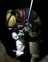
-Plan on taking more time per foot than you do in small passages, even though the shots are long. Make sure you have a patient team and/or give them something like photos to do. Sketcher blowout is a common phenomenon in passages like this.
-Use big paper if at all possible.
-Carry a sketcher disto and measure distances to objects of interest, it is very easy to guess a boulder is some distance away and discover you were wrong which then gets in the way later on.
-Tend towards setting more stations/splays/whatevers that define the passage shape early on.
-Force your station setters to do no more than 100ft shots unless it is really boring passages.
-Don't try to draw everything but preserve the orientation of some major features. Sketchers vary on this but I like to draw some of the more obvious boulders to scale but then end up filling in with symbols for the rest since it takes to long to draw every rock.
James
- hunter
- NSS Hall Of Fame Poster
- Posts: 395
- Joined: Sep 9, 2005 9:47 am
- Location: New Mexico
Re: Surveying large passage for the first time
![]() by Martin Sluka » Sep 21, 2012 2:31 pm
by Martin Sluka » Sep 21, 2012 2:31 pm
No any problem for me with DistoX and PocketTopo. Just one important think: I always measure 3-5 splay shots and draw cross-sections, walls, details. Then again several shots and draw again. An so on. Because if you'll measure 15 splay shots you should be totally lost. Exactly this method use professional surveyors. Main shots and ancillary (splay) shots.Anonymous_Coward wrote: Adding a separate category of "splay measures" seems complicated, confusing, and unnecessary.
-big paper or several hard sheets you may put together:

-
Martin Sluka - NSS Hall Of Fame Poster
- Posts: 402
- Joined: Mar 17, 2006 11:28 am
- Location: Prague, Czech Republic
- Name: Martin Sluka
- NSS #: 29010
Re: Surveying large passage for the first time
![]() by AndrewA » Sep 27, 2012 4:06 am
by AndrewA » Sep 27, 2012 4:06 am
- Code: Select all
*flags splay

<data>

*flags not splay
However, it does require station names on both stations, which PocketTopo does not support, not sure about Auriga. But I believe that survex will support splays without names (using "-") shortly (seen a test version working on expedition this year.)
I personally am a massive advocate of paperless surveying and the improvements it has made to the drawing of cave passages. Or at the very least drawing to scale (use the therion protractor {and that does not mean you have to use therion, just a very useful tool that they produced)
But the key to good surveys are lots of splays to identify features and points and join them together, and the only practical way of doing that is with a DistoX (or similar tool) and a pda. The other advantage of all in one electronic measurements is that the reading time is reduced, so it is practical to take more shorter legs. Unfortunately the drawing is still the slow bit, but again splays and a pda improve that a bit.
- AndrewA
- Infrequent Poster
- Posts: 5
- Joined: Dec 13, 2011 4:08 am
Re: Surveying large passage for the first time: The results
![]() by GroundquestMSA » Oct 3, 2012 8:52 pm
by GroundquestMSA » Oct 3, 2012 8:52 pm
I'd appreciate your criticisms of my map, based on the methods used. I've no survey software and I regret that I am not an artist. The x-sections are admittedly a bit childish, but I felt I needed to represent some of the massive speleothems more fully than their symbols on the plan veiw were able. If any of you still do most of your mapmaking by hand, I'd love some tips.
Page 1- http://i1241.photobucket.com/albums/gg515/GroundquestMSA/Anonymous.jpg
Page 2 - http://i1241.photobucket.com/albums/gg515/GroundquestMSA/Anonymous1.jpg
Thanks -J
-
GroundquestMSA - NSS Hall Of Fame Poster
- Posts: 1384
- Joined: May 5, 2011 1:32 pm
Re: Surveying large passage for the first time
![]() by BrianFrank » Oct 4, 2012 10:26 am
by BrianFrank » Oct 4, 2012 10:26 am
Quest. 1.) At the very south west end of the first map I see a stream that hits 1'. I assume that is a sump. Have you tried to get through that or dig to see if it goes? That looks like the only possible exit to this cave?
Quest. 2.) Any airflow in the 7' (100') solutional crawl that you may want to do a dig later?
All TAG cavers join http://www.SCCI.org. A small price for a GREAT resource.
-
BrianFrank - NSS Hall Of Fame Poster
- Posts: 455
- Joined: Apr 5, 2011 11:25 am
- Location: Alpharetta, GA
- Name: Brian
- NSS #: 52121
- Primary Grotto Affiliation: Dogwood City Grotto
Return to Survey and Cartography Forum
Who is online
Users browsing this forum: No registered users
 Cavechat is the official caving forum of the National Speleological Society.
The NSS is not responsible for the opinions expressed, and cannot verify the accuracy of information presented.