But we'll never get the best possible digital cartographic product by producing it in the harshest, most unergonomic environment imaginable.
And what? it will be gotten by paper and pencil.....rofl
In Cave Digital Survey(ICDS) is still in its earliest stages.
However, ICDS even at this early stage facilitates faster sharing capabilities and has the potential to capture a whole lot more relevant data!
Where gains will be really made is when others jump on board and we begin sharing Illustrator brush stroke libraries, symbols libraries, fill libraries, and much more.
My new site will be designed with just this in mind i.e. a place to download shared libraries and learn how to use them to gain radical efficiencies.
What will result is the ability to produce
STUNNING In Cave Digital Surveys just days after finishing the in cave working trip.
The New Site Address is:
http://www.InCaveDigitalSurvey.com In Cave Digital Survey(ICDS)An experienced Adobe Illustrator sketcher who has his/her device loaded with elaborate and carefully created brush, symbol, and fill libraries can generate a far far more detailed working map in far less time while in the cave. For instance the ICDS sketcher can brush in a whole section of cobbles, a complex boulder pile, a massive mud slope, or a pool with full color in a few clicks and strokes!
The key is an investment of time at the front end i.e. symbols, custom brush strokes, boulders, cobbles, pools, fills etc. Different parts of this can be done by different ICDS folks from around the globe and shared for download by all!
Most importantly in all this is that prices are dropping on the technology so even more doors open for capturing even more data with the same device. For instance the ability to capture audio at each station by the ICDS sketcher. This will become an invaluable part of the online working map. It is simple for those ICDS minded that decide to put themselves at the helm of the ICDS project. Simply record the audio then make a link on the station on your online working map. Then six months later a crew looking at a lead list can click on a station near a lead marked on the working map and hear what the ICDS sketcher and team relayed about the lead.
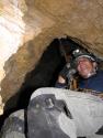
Here is my newest ICDS rig It specifically is a Fujitsu Stylistic ST5010 coupled with an Otterbox 4600

I was just reviewing your current version of the Zicafoose map- there is a dearth of profiles and cross sections; it would be particularly cool to see the overlapping cross sections- you do have that data, yes?
Correct...most of the cave was sketched on paper largely by Bob Kirk and others. They along with other details left off the working map will be on the finished map.
Only a fraction of Zicafoose was done by ICDS...ah if I only knew then what I know now. Plus the right gear is now beginning to priced right and things like the Otterbox 4600 coming to market(finally).
I will recap a little of the history.
I chose Walls because of a presentation I saw at the California Convention. At that point I had never used Illustrator or Walls but decided to give it a go. I ended up spending quite a bit of time corresponding with David McKenzie working through various issues and hurdles. Then began experimenting with the In Cave Digital Survey(ICDS) idea in a cave.
Zicafoose
Parts of the 1st and 2nd drop area of the cave was done using a "borrowed" Getac ruggedized touchscreen laptop. It was
very much a trial and error process but it went well enough to continue the path toward In Cave Digital Survey(ICDS).
Then I decided because of "budget" to buy a very inexpensive Fujitsu Stylistic 2300(ebay), PII, running Win98, Illustrator 10 and Walls. It is a pure tablet and slow so text entry was a royal pain in the ass. However it lit me on fire with the possibility because it worked......albeit the data crew had to have exceptional patience as the processor sludged through the roundtripping of the SVG. This Fujitsu Stylistic actually did a decent amount of cave surveying in the back of Zicafoose.
I then purchased a Panasonic Toughbook convertible tablet(very pricey) which I used a bit and then sold to Aaron Addison. I think Martin Sluka has one of these as well.
I now have:
1) a great inexpensive($400 ebay), lightweight convertible notebook/tablet i.e. Toshiba Portege M205
2) and a Panasonic Toughbook with touchscreen Notebook
3) and a ST5010 Fujitsu Stylistic tablet(ebay inexpensive)...very fast....long battery life...I have 2 batteries and will order another for some upcoming ICDS trips.
4) And a Otterbox tablet case specifically built for this Fujitsu Tablet series. More info. on this at
http://www.otterbox.com/products/pc_cases/tablet/ with a pic below.
if the Disto will travel there then the ICDS will now go as well.
My goal moving forward is to reorder the process for 2 different types of ICDS's which will:
*Reduce total man hours ICDS vs Traditional by 20-40% depending on which routine is chosen
*Produce less chance for errors
*Generate twice as many relevant survey vectors for the drawn to scale ICDS sketcher
*Include voice data at each survey station that can be ran through Dragon software and extracted as text(or it can be loaded as audio links to the working map) and then added as "links"to each survey station on the online working map(with fast connections now the audio will be the fastest route to go).
*Speed up ICDS sketching through shared libraries.....very few if any paper sketchers on a traditional survey routine will be able to keep up with the sketcher at the helm of this reworked ICDS process.
*Reduce battery consumption by 40-50% vs previous ICDS process for the same footage surveyed.
I will be updating
http://www.InCaveDigitalSurvey.com and welcome any content that others experimenting with the process want to submit or share...i.e. Illustrator symbols, boulders, fills, libraries etc.
Mark Passerby, Cavediggers.com