Underground altimeter use

Discuss caving lights, packs, helmets, clothing, etc.
For rope and vertical equipment, go to the On Rope! forum.
Cave electronics enthusiasts can also visit the Communications and Electronics Section forum.

Moderator: Moderators

Underground altimeter use

Postby Anonymous_Coward » Apr 2, 2009 10:59 am

After bringing it up in another thread, I was asked to start one about my altimeter that I use underground.

This is the one I have:
http://www.thealtimeterstore.com/highgear.html

I like it because it doubles as a watch. Also, the carabiner clip thing hinges so I can stick it in a dashboard vent and use the altimeter in the truck. Kind of fun when you're cruising up and down mountain roads. That's really the reason I wanted to get a dashboard altimeter. My wife got me this one for Christmas 2007 so I could also use it on backpacking and ski trips. Only later did I get the idea to use it in barometric caves.

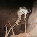
Often, when we go out to the end of Jewel Cave and feel wind blowing, it leads to more cave. Jewel breathes barometrically, and there is only one known entrance. On a day trip, we know which way the wind is blowing at the entrance and that helps us to determine which leads to pursue. For example, if the cave is blowing out, wind blowing out of a lead should be coming from unknown cave. If wind is blowing into a lead when the entrance is blowing out, then that wind is probably going toward the entrance.

This sounds fairly simple except when you take into account that the cave wind can change direction at any moment. So, at the end of the cave you don't really know which direction the wind is going, unless you can correlate it with a known point in the cave. This gets particularly difficult on camp trips, when we are underground for 4 days. On the way to the southeast part of the cave from camp, we go through a place called The End, that is small and you can feel the wind there. That is the last place that we really can tell which way the wind is going until hours later when (hopefull) we start exploring windy leads. (and then you don't really know if it has flipped) We sometimes go beyond The End for 24 hours, and the wind direction can sometimes change several times in a day.

On the last camp trip in January, I took the altimeter and used the barometer setting to monitor pressure changes. A dropping barometer in the cave should mean outflow and a rising barometer should mean inflow. There are factors that complicate this, but generally it is true. Using the barometer on the survey trips we were able to make a more educated guess about which leads would take us farther from the entrance.

Last month, I took the barometer/altimeter to the Far East in Lechuguilla cave for 8 days. The barometric winds are much harder to feel in Lech than in Jewel. I don't know if this means it is a smaller cave, or just that the air behaves differently because of different cave geometry. At any rate, the barometer stayed fairly flat all week. Only on the last two days did it show the pressure dropping significantly. Interestingly enough, when I checked the surface pressure history after the trip, that is sort of what actually happened on the surface as well. Check out March 15-21 on this Carlsbad pressure graph:

Image

While the instrument is not as useful for wind in Lech, it is very fun to use for depth. Like any altimeter it does need to be calibrated from time to time to account for pressure changes, but on a long trip I am not really using it for "to-the-foot" elevations above sea level. I do use it for relative depth from place to place and found that it is definitely accurate enough to gauge pit depth. I would trust a rope measurement derived from this thing. You can hold it in your hand and watch the numbers change as you raise or lower it one foot. I haven't checked it against a laser for pit depth but I plan on doing that soon.

On shorter trips, you can trust it to give absolute elevation. I recently took it to the bottom of Neff's Canyon Cave in Utah. Neff's is 1186' deep and the altimeter told us just where we were on the profile the whole trip. When we got to the Bedroom Complex the altimeter showed 600' below the entrance-halfway down. Looking at the map I saw that we were indeed halfway to the bottom. At the bottom it read 1191' below the entrance, so pretty close to spot on. It was also fun on the hike down from the cave to see when we were level with the elevation of the sump at the bottom of the cave.

Anyway, there are some of the things I have been playing with with the altimeter. It's another fun geeky device to carry around in a cave if anyone was looking for one. (I know there are no geeks that read this board :waving: ) On the next camp trip I plan on not being lazy and actually recording the pressure morning and night and seeing what I can learn from that, correlated with wind observations at the leads and pressure history of the surface.
Andy Armstrong
American Carbide Council
User avatar
Anonymous_Coward
NSS Hall Of Fame Poster
 
Posts: 895
Joined: Feb 3, 2006 1:40 pm
Location: Inside the Beehive
NSS #: 45993RL FE
Primary Grotto Affiliation: Paha Sapa Grotto
  

Re: Underground altimeter use

Postby NZcaver » Apr 2, 2009 1:49 pm

Great information. Thanks, Andy!

Sounds like your one has been pretty useful in certain situations. Might have to add one of these to my wish list. :pray:
User avatar
NZcaver
Global Moderator
 
Posts: 6367
Joined: Sep 7, 2005 2:05 am
Location: Anchorage, Alaska
Name: Jansen
NSS #: 50665RL
  

Re: Underground altimeter use

Postby OpenTrackRacer » Apr 2, 2009 2:46 pm

Very interesting information. I also use an altimeter when exploring mines. I have a Brunton Sherpa which also has a anemometer...

Image

My main use is for estimating depth but and anemometer has also been helpful when looking for other openings like Andy has done with his barometer in caves. I can see these being very useful devices in both environments and they're very useful on the surface as well.

Mike
Underground Explorers
California Abandoned Mine Exploration
http://www.undergroundexplorers.com
User avatar
OpenTrackRacer
Prolific Poster
 
Posts: 189
Joined: Jul 1, 2008 1:05 am
Location: San Diego, CA
Name: Mike Schriber
NSS #: 65042
Primary Grotto Affiliation: Southern California
  

Re: Underground altimeter use

Postby trogman » Apr 3, 2009 9:19 am

Interesting use for your altimeter! I was wondering, though, if the direction and wind speed was also correlated with the outside temperature. I know it seems to be here in TAG. Almost all significant-sized caves around here blow at the upper entrances when it is cold outside, and vice-versa. I was just thinking that this would also be a factor as well.

On another note, how often do you usually have to calibrate your altimeter? I just recently got a Garmin GPSMap 76CSX, which has a built-in altimeter. I try to set it at the start of my ridgewalk, and some days it seems dead on. But other days, it seems like it fluctuates a lot. I guess it all depends on how much the atmospheric barometric pressure is fluctuating, but I was curious what kind of correlation there is between barometric pressure fluctuation and the altitude reading. In other words, how much difference, in feet, would it make, if the barometric pressure rose or fell X amount? If it's only 5 or 10 ft., I could live with that. If the error starts getting to 50 or 100 ft., that could be a problem. I do love having a more accurate altitude reading now; at least it's better than the old GPS altitude that was calculated from the satelites.
User avatar
trogman
NSS Hall Of Fame Poster
 
Posts: 1017
Joined: May 2, 2008 8:35 am
Location: North Alabama
Name: Stephen Brewer
Primary Grotto Affiliation: Gadsden Grotto
  

Re: Underground altimeter use

Postby Scott McCrea » Apr 3, 2009 9:36 am

Thanks, Andy!

High Gear stuff (made in Asheville, btw) shows up on Steep and Cheap occasionally, usually about 50 percent off.
Scott McCrea
SWAYGO
User avatar
Scott McCrea
Global Moderator
 
Posts: 3198
Joined: Sep 5, 2005 3:07 pm
Location: Asheville, NC USA
NSS #: 40839RL
Primary Grotto Affiliation: Flittermouse Grotto
  

Re: Underground altimeter use

Postby Anonymous_Coward » Apr 6, 2009 12:19 pm

Hi Trogman,

What you're saying is true for chimney caves, but not for barometric caves where pressure changes are much more important than temperature. In a big cave with only one entrance, the cave just breathes in and out trying to equalize with surface pressure changes. In a big enough cave like Jewel, those winds can move up to 35 miles an hour up to a mile from the entrance.

I calibrate the altimeter whenever it seems off. If I'm going to be using it for something critical, I will calibrate it with a topo map or highway elevation sign. (although I have found the signs to vary wildly in accuracy) I usually calibrate it in my driveway, where I know the elevation to be 7200'. I have found that if the weather is stable, the altimeter will stay highly accurate (within 10-20 feet) for several days. All bets are off however if a big storm or front moves through. This can throw it off by up to 200 feet in less than an hour. When I'm just using the altimeter for driving around, I might go weeks without calibrating it. I have found that the fluctuations tend to more or less even out over time. Usually if it reads within 100 feet of a known elevation, I just leave it alone.
Andy Armstrong
American Carbide Council
User avatar
Anonymous_Coward
NSS Hall Of Fame Poster
 
Posts: 895
Joined: Feb 3, 2006 1:40 pm
Location: Inside the Beehive
NSS #: 45993RL FE
Primary Grotto Affiliation: Paha Sapa Grotto
  

Re: Underground altimeter use

Postby Phil Winkler » Apr 6, 2009 12:56 pm

Andy's post reminds me of measures you can take when planning a trip where knowing whether (pun) barometric pressure change will occur is important. Sailors and others who venture offshore know to use weather maps from NOAA to view the isobars which are lines of similar barometric pressures. They are much more detailed then the weather maps you see on the News, but generally show areas of highs and lows and how fast they are moving.

Aviators use them all the time, too. Of course, they are available online.
http://ww2010.atmos.uiuc.edu/(Gh)/wx/cwp/prods/current/sfcslp/sfcslp_N.gif

With a little drilling down you can get much more localized data.
Phil Winkler
13627 FE
User avatar
Phil Winkler
Global Moderator
 
Posts: 2375
Joined: Sep 5, 2005 8:48 am
Location: Wilmington, DE and Dewey Beach
NSS #: 13627FE
  

Re: Underground altimeter use

Postby NZcaver » May 3, 2009 3:53 am

jaa45993 wrote:After bringing it up in another thread, I was asked to start one about my altimeter that I use underground.

Thanks to you Andy, I have now acquired an altimeter/barometer/thermometer/weather-predicting watch. :woohoo:

I looked at some models made by Highgear, Brunton and Suunto... but ended up with a Timex Expedition. I read several online reviews about Highgear wristwatches which revealed that sometimes they can spontaneously lose their settings for no reason - permanently. So I decided to play it safe with this Timex, which people only seem to complain about the wrist band (which seems fine to me).

Image

It doesn't have the electronic compass, but that wasn't too big a deal breaker for me. It's a nice watch, and finding one in near-perfect condition on eBay for under $30 was better than paying $100 retail. I prefer using a wristwatch to clip-on watches. Aside from taking it off the wrist to get an accurate temperature reading, I find it much more convenient. And its -10C rating should reduce the risk of it dying/resetting in the cold like my last watch did.

Of course I haven't actually used it caving yet (no caves around) but I intend on doing some high country backpacking with it soon.
User avatar
NZcaver
Global Moderator
 
Posts: 6367
Joined: Sep 7, 2005 2:05 am
Location: Anchorage, Alaska
Name: Jansen
NSS #: 50665RL
  

Re: Underground altimeter use

Postby Caveair » May 6, 2009 12:31 pm

"Last month, I took the barometer/altimeter to the Far East in Lechuguilla cave for 8 days. The barometric winds are much harder to feel in Lech than in Jewel. I don't know if this means it is a smaller cave, or just that the air behaves differently because of different cave geometry. At any rate, the barometer stayed fairly flat all week. Only on the last two days did it show the pressure dropping significantly."

Hi Andy,

Nice article - on the use of an altimeter underground. I got to use one myself (borrowed) in the entrance of Lechuguilla Cave back about 20 years ago. I also brought along my portable recording barometer too, but found the portable one to be much less usefull for doing quick and interesting stuff - such as taking a reading at the top of Lechuguilla's culvert entrance when it was blowing about 30+ mph, and another down at the bottom end about 10 feet from the tube exit. There was something like a -13-millibar difference........ Wow!

So, your observation that, "the barometric winds are much harder to feel in Lech than in Jewel" is very interesting. You know that the "map" of Jewel Cave - shows that the cave tends to be "compartmentalized" into big sections, with multi-mile
sections of virgin cave to be found in each new section as a bypass/breakthrough is found. Examples are: the hard-rock dig that opened up the whole Western Section going into the West Wall of Hell Canyon. Another compartment wall is the Misseries. (There's been note that faulting is causing the compartment/brick pavement like internal structure.) There are also several other places where cave survey's come within feet of each other - but the tour to reach the other side requires several miles of backtracking.

So, your comment that you can find strong blowing leads in Jewel, and not in Lech gave me an idea - to visualize "Jewel Cave" barometric wind as flowing thru sort of like a "fish ladder" - with its compartmented structure. You would have a lot of cave far back beyond the explored end of the cave; but most of the air would be having to flow thru each pool/compartment of the fish ladder, thru the connector passage, in order to exit at the cave's entrance. Thus you have higher wind velocities than expected much further back from the entrance than one would expect.

At Lechuguilla, on the other hand; I remember being somewhat shocked that I had such a significant pressure differential recorded just between the top and bottom of the culvert. When I first noted it I thought that I was seeing a large percentage of the total barometric pressure differential causing the culvert cave winds happening right there. To me it seemed right then and there that descending the culvert in Lechuguilla - was like crawling thru a spillway of a large dam - and getting onto the surface of a smooth, large lake/cave on the top side........

If true this could mean that tracer gases, or scents such a vanilla would have to diffuse to the entrance of Lech - rather than "ride the current" with the barometric wind of Jewel.

So, does this also mean that Lechuguilla is not compartmentalized, but in a much more homogenious/uniform strata such as the ancient barrier reef there?

Bruce "CaveAir" Zerr
Caveair
Infrequent Poster
 
Posts: 6
Joined: Sep 12, 2005 9:59 pm
  

Re: Underground altimeter use

Postby Anonymous_Coward » Jul 21, 2010 6:06 pm

Bruce,

Interesting post. Sorry I didn't see it until now, more than a year later!

I think you are correct about the "compartmentalized" nature of Jewel Cave.

I also think that the muted readings in Lechuguilla are due to the airlock that was installed in 2000. If it was left open, I'm sure the readings at the ends of the cave would be more exciting.
Andy Armstrong
American Carbide Council
User avatar
Anonymous_Coward
NSS Hall Of Fame Poster
 
Posts: 895
Joined: Feb 3, 2006 1:40 pm
Location: Inside the Beehive
NSS #: 45993RL FE
Primary Grotto Affiliation: Paha Sapa Grotto
  

Re: Underground altimeter use

Postby Cody JW » Jul 21, 2010 8:25 pm

I have a Suunto altimiter I bought at an outdoor store going out of business sale.Since we are on the subject I was wondering about setting your reference to the barometric pressure from the weather on the TV news. Is this reliable? When I ridgewalk I take both a gps and this altimiter, this one is made for mountain climbers, it has a barometer setting for incomming weather and an altitude mode.The altimiter comes in handy to check how high on the mountain I am as I move where the gps I assume tells you your altitude based on your location. If I am in Scottsboro Al and getting weather from TV in Chattanooga or Huntsville will setting from current barometric pressure instead of known altitude be relible? The reason I ask is when I do this and get to my start point I check the altimiter to what the GPS says my altitude is and I see a difference.The GPS does not show your altitude constantly as you move but the altimiter will.I find this useful if you need to maintain an elevation as your contour the hillside.I do know I have to change this one from weather mode, where it says change in barometric pressure is weather related or Altimiter mode where it says changes in barometric pressure is altitude related.If the altimiter is set correctly will it be more reliable than the altitude on a GPS?
It only takes one person to surrender a dog to a kill shelter ,but it takes many to rescue it.
User avatar
Cody JW
NSS Hall Of Fame Poster
 
Posts: 905
Joined: Oct 24, 2007 10:16 am
Location: Indianapolis In. USA
Name: Jeff Cody
NSS #: 23961


Return to Equipment Forum

Who is online

Users browsing this forum: No registered users