Cool Tools wrote:Google Earth DOES work even when disconnected from the Internet.
GPS & Google Earth Solution
Cost-effective GPS mapping in real time
From Kevin Kellys Cool Tools
Link: http://tinyurl.com/yv7nqw
[center]
 [/center]
Cool Tools wrote:I have been doing a lot of exploring and surveying in the desert recently, and have been trying to find the right GPS mapping solution. The solution I found incorporated stuff I already had (laptop and GPS) with the help of some excellent, nearly free software. The best part is that it works even better than the $900 in-car GPS solutions as it uses always up-to-date satellite data, and is easily sharable.
Basically you run Google Earth and use some great donation-ware to link it in real time to a GPS. This means that your mapping software and maps worldwide are not only free, but you also get hi-res satellite views and in some cases 3D buildings (in downtown areas). Only a year or so ago this would have cost tens of thousands of dollars in proprietary GPS mapping gear; it would be difficult to share it once done; each map and satellite shot would cost extra; and it would have been an ordeal to get it all loaded up and working properly for each area you wanted to go.
What you need... (my set up is listed below). To get started you need a computer that can run Google Earth and you need a GPS. If you want this setup to be mobile, it's of course best to use a laptop, and if you plan on using it as a primary navigation solution, I would suggest a tablet PC or UMPC with a daylight-readable screen. I use a hand-me-down Fujitsu Stylistic 5000 tablet PC that I keep in a "ruggedized," water-resistant case with drop protection by Otterbox. Tablet PCs and UMPCs are great for in car use as they have daylight readable screens, and their touch screen interface and form factor are easier to use in a vehicle. The Fujitsu ST 4000 and 5000 also happen to fit the Otterbox case for a very rugged combo.
To connect the GPS to Google Earth on a PC I recommend Goops (there are a couple other options out there like Earth Bridge, but I have not tested them yet). For Mac you will need GPS2geX).
The GPS I use is the tiny Globalsat BT 359, which has a very long battery life and works wirelessly by Bluetooth to my Mac, PC and even my Treo (there are also some GPS's that have data logging memory built in like the DG-100 and TrackStick, though I have not used these yet). This style of GPS is only meant to be used in conjunction with another device as it has no screen or memory.
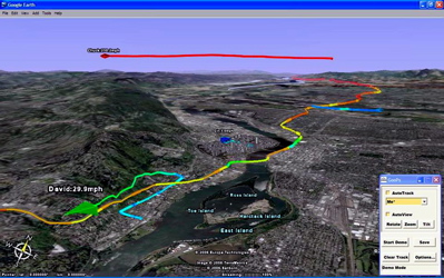
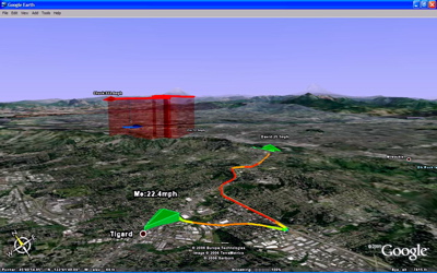
So once you have a GPS and your laptop has the right software, you will need to pair your GPS to the laptop via Bluetooth and make sure it's recognized by Goops (or whichever linking software you are using). You are now able to track your real time position and history in Google Earth. Goops can even color code your track history based on your speed (red for fast; blue for slow), and give you speed and altitude data on the fly. You can also track multiple networked units as well. Below, the red, levitated track is a plane. Cont.: http://tinyurl.com/yv7nqw
[center]
 [/center]
